What is SHAHIIN D-22?
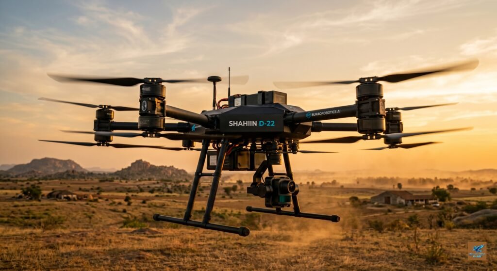
SHAHIIN D-22 is an advanced autonomous quadcopter drone engineered and assembled from scratch by BURAQROBOTICS AI in Ramanagara, Karnataka, India. Built on a professional-grade Tarot 650 carbon fiber frame with a 650mm motor-to-motor wheelbase, it is powered by high-torque 5010 360KV brushless motors, 15-inch carbon composite propellers, and a custom in-house built 22V Molicel P30B lithium-ion battery pack. Flight intelligence is delivered by the RadioLink PIX6 autopilot running ArduPilot/PX4 firmware — enabling fully autonomous GPS-locked flight, waypoint missions, and intelligent return-to-launch.
SHAHIIN D-22 is not a single-purpose commercial drone. It is a modular UAV platform — meaning the same airframe is engineered to accept different mission payloads across four progressive upgrade phases. One drone. One investment. Unlimited operational scope across agriculture, logistics, construction, events, and AI-based operations.
SHAHIIN D-22 is not a military drone. Not a defense system. Not a consumer toy. It is a professional-grade commercial UAV platform built exclusively for Indian businesses, government agencies, research institutions and Warehouses Stock Monitoring.
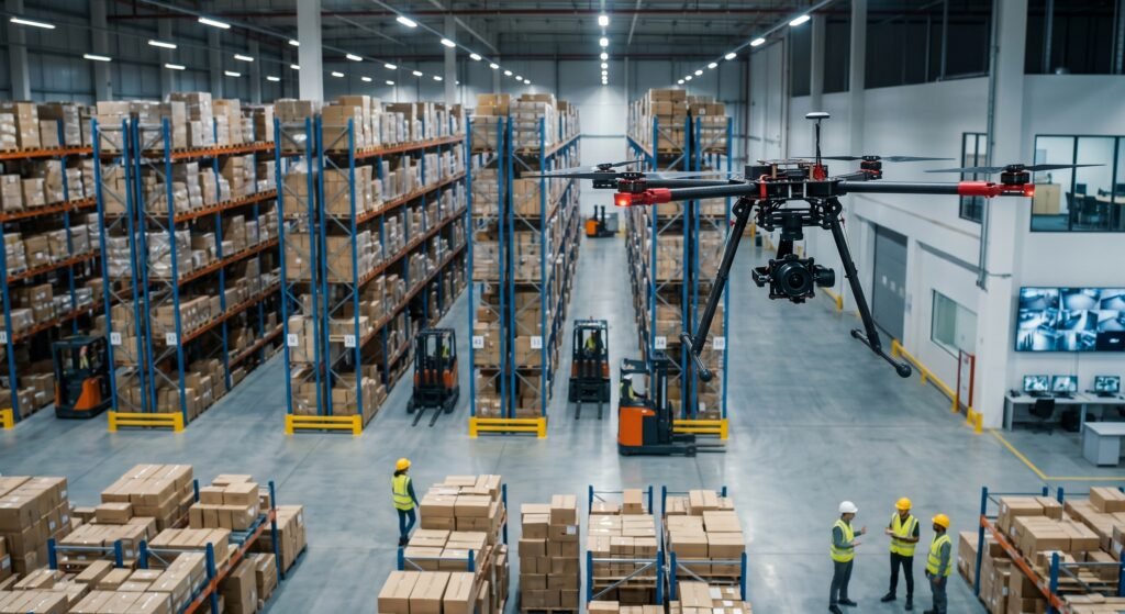
What Can SHAHIIN D-22 Do? Warehouse Surveillance Drone.
SHAHIIN D-22 is engineered in phases — each phase unlocking new mission capabilities through modular hardware and software upgrades, without replacing the core platform.
Phase 1 — Current Capabilities (Available Now), SHAHIIN D-22 Autonomous Quadcopter.
Autonomous Stable Flight: SHAHIIN D-22 uses the RadioLink PIX6 advanced autopilot running ArduPilot/PX4 firmware to deliver fully autonomous GPS-locked flight. It can take off, hold position, follow waypoint missions, and return to launch — all without manual pilot input.
Precision Positioning: Equipped with the Holybro M10 Standard GPS module, SHAHIIN D-22 achieves 2.5m CEP horizontal position accuracy. It holds its position precisely even in moderate wind conditions — essential for survey, monitoring, and payload delivery operations.
Long Range Control: The Skydroid T10 10-channel transmitter and R10 receiver provide a robust, low-latency control link over long operational distances — far beyond standard RC drone systems. Ideal for large-area operations over warehouses, farmland, and construction sites.
Heavy Lift Capability: With 5010 brushless motors and 15-inch propellers, SHAHIIN D-22 sits in the professional heavy-lift class. It can carry significant payloads — cameras, sensors, delivery packages — while maintaining stable flight characteristics.
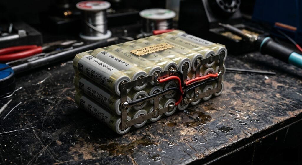
Custom Power System: The heart of SHAHIIN D-22 is its custom-built 22V lithium-ion battery pack, hand-assembled in-house by BURAQROBOTICS AI using 18 Molicel P30B cells. This gives better energy density than standard LiPo batteries, safer chemistry, and a much longer charge cycle life — engineered for professional operations.
Phase 2 — Near Future Capabilities (Coming Soon)
These upgrades are being actively developed and will be available as plug-and-play modules on the same SHAHIIN D-22 platform:
- Flower & Seed Dropping: Servo-controlled payload release mechanism for weddings, cultural events, agricultural seeding, and corporate celebrations. Precise, timed release from altitude.
- Agricultural Crop Mapping: Multispectral camera integration for NDVI crop health analysis, vegetation mapping, and precision agriculture field data collection.
- Construction Site Monitoring: High-resolution downward camera system for automated site progress documentation, safety inspections, and stakeholder reporting from above.
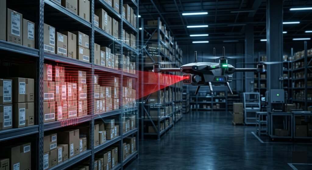
- Warehouse & Stock Surveillance: Wide-angle camera payload for aerial inventory monitoring, stock count verification, and facility oversight in large logistics facilities.
Phase 3 & 4 — Advanced Future Capabilities
These are the long-term upgrade missions that the SHAHIIN D-22 platform has been architecturally designed to support from day one:
- 3D Mapping & Photogrammetry: Professional survey-grade aerial mapping using photogrammetry software such as OpenDroneMap — generating accurate 3D terrain models and orthomosaic maps.
- Thermal Imaging: FLIR thermal camera integration for heat detection, moisture mapping, electrical inspections, and night operations.
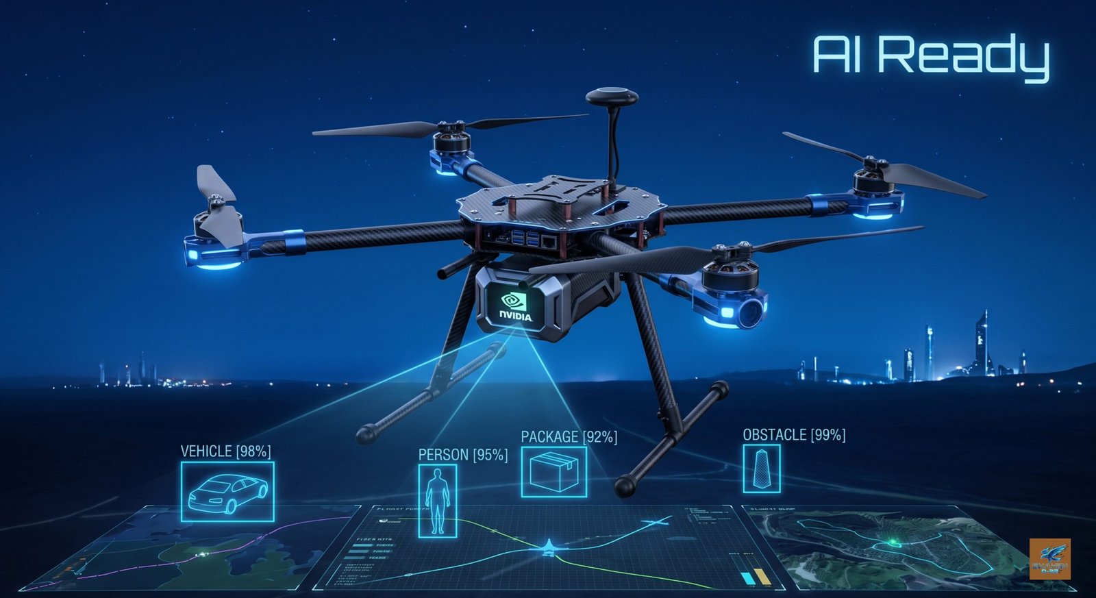
- AI Computer Vision: NVIDIA Jetson companion computer integration for real-time object detection, tracking, counting, and autonomous decision-making.
- Long Range LTE Operations: 4G/LTE telemetry link for beyond visual line of sight (BVLOS) operations across large areas.
- Emergency Response: Integrated searchlight, thermal camera, and speaker system for search-and-rescue and disaster response operations.
- RTK Precision GPS: Centimeter-level accuracy GPS for precision agriculture and professional survey work demanding the highest positional accuracy.
Full Technical Specifications: Remote Control Drone
Airframe:
| Model | Tarot 650 Foldable Quadcopter |
| Configuration | Quadcopter — X Configuration |
| Material | Carbon Fiber Composite |
| Wheelbase | 650mm (motor to motor) |
| Arms | 4 — Foldable Design |
| Frame Weight | Approximately 800g |
| Max Takeoff Weight | 1.5 – 3 kg (estimated, payload dependent) |
| Finish | Matte Black Anodized |
Propulsion:
| Motors | 5010 Brushless x 4 |
| KV Rating | 360KV (High Torque) |
| Best For | Heavy Lift Payloads |
| Propellers | 15 inch — 2 blade |
| Prop Material | Carbon / Nylon Composite |
| Configuration | 2x Clockwise + 2x Counter-Clockwise |
Power System
| ESC | Hobbywing XRotor FPV G2 |
| ESC Type | 4-in-1 Unit |
| ESC Rating | 45A Continuous |
| System Voltage | 22V (6S Equivalent) |
| Battery Type | Custom Built In-House |
| Battery Cells | Molicel P30B x 18 cells |
| Battery Chemistry | Lithium-Ion (Li-Ion) |
| Battery Voltage | 22V Nominal |
| Built By | BURAQROBOTICS AI Lab, Ramanagara |
Flight Systems:
| Flight Controller | RadioLink PIX6 |
| FC Type | Advanced Autopilot |
| Firmware | ArduPilot / PX4 |
| Flight Modes | Manual, Stabilize, AltHold, Loiter, Auto, RTL, Land |
| GPS Module | Holybro M10 Standard |
| GPS Connector | GHR 1.25mm 10-pin |
| GPS Accuracy | 2.5m CEP (Standard) |
| Compass | Built-in |
Control System:
| Transmitter | Skydroid T10 |
| Receiver | Skydroid R10 (included) |
| Channels | 10 Channels |
| Control Range | Long Range Capable |
| Video | Optional FPV Capable |
| Telemetry | Compatible |
Industries We Serve:
SHAHIIN D-22 is engineered to operate across six major commercial sectors in India — currently serving Bangalore, with expansion planned across Karnataka, Andhra Pradesh, Telangana, Tamil Nadu, and Maharashtra.
Logistics & Warehousing, Warehouse Surveillance Drone India
Large warehouses and distribution centres face a constant challenge: monitoring stock, verifying inventory counts, and surveying facilities that span thousands of square metres. SHAHIIN D-22 with a wide-angle camera payload gives logistics managers an aerial view of their entire operation in minutes — not hours. Identify misplaced stock, monitor high-rack storage areas, and generate aerial inventory reports without scaffolding or manual floor walking.
Who it serves: Warehouse operators, distribution centres, e-commerce fulfilment facilities, large retail storage operations.
Construction & Infrastructure
Construction projects generate enormous amounts of progress data that is almost impossible to document efficiently from the ground. SHAHIIN D-22 flies your construction site on a scheduled basis, captures high-resolution aerial imagery and video, and delivers a visual timeline of your project from above. Stakeholder reporting, safety audits, and progress verification become faster, cheaper, and far more compelling.
Who it serves: Builders, property developers, infrastructure companies, civil engineering firms, project managers in Bangalore and major Indian cities.
Events & Celebrations, Flower drop Drone for Wedding Bangalore
Make your event unforgettable. SHAHIIN D-22 with a servo-controlled payload release mechanism can drop thousands of flower petals, seeds, or confetti from altitude at the perfect moment — weddings, corporate events, cultural celebrations, product launches, and community functions. Combine with an aerial camera and you get both the spectacle and the cinematic memory of it.
Who it serves: Wedding planners, event management companies, corporate event teams, cultural organisations, PR and experiential marketing agencies across Bangalore and South India.
Government & Municipal
Urban planners, municipal bodies, and state government agencies require accurate land survey data, infrastructure condition assessments, and disaster impact documentation. SHAHIIN D-22 delivers aerial data at a fraction of the cost of manned aircraft — enabling land surveys, urban development mapping, infrastructure monitoring, and post-disaster area assessment across Karnataka and beyond.
Who it serves: State government agencies, urban local bodies, Smart City missions, BBMP, infrastructure departments, disaster management authorities.
Research & Education
Universities, engineering colleges, and research laboratories across India need UAV platforms for aerial data collection, robotics research, autonomous systems experiments, and field studies. SHAHIIN D-22 is an open, documented, ArduPilot-based research platform — compatible with MATLAB, ROS, and custom Python flight scripts. Its transparent build documentation makes it ideal for academic institutions that want to understand and extend the platform, not just operate it.
Who it serves: IITs, NITs, engineering colleges, agricultural universities, robotics labs, AI research groups, and STEM education institutions.
Frequently Asked Questions
Q: Is SHAHIIN D-22 Drone available for purchase, hire, or both?
A: SHAHIIN D-22 is currently available for commercial service hire in Bangalore for specific missions including aerial survey, construction monitoring, and event operations. Custom builds and direct purchase inquiries are also open. Contact BURAQROBOTICS AI to discuss your specific requirement.
Q: What payload can SHAHIIN D-22 carry?
A: In Phase 1, SHAHIIN D-22 operates in basic autonomous flight mode without additional payload. Phase 2 upgrades enable 500g to 1kg payload capacity — covering cameras, gimbals, and sensor packages. Phase 3 targets 1 to 2kg, and Phase 4 will exceed 2kg with a power system upgrade. Exact capacity depends on battery configuration and flight time requirements.
Q: Is SHAHIIN D-22 a military or defense drone?
A: No. SHAHIIN D-22 is a commercial-sector UAV platform. It has no defense or military application, no weapons integration, and is not designed for any defense purpose. It is built exclusively for commercial industries including agriculture, logistics, construction, events, and research.
Q: How long can SHAHIIN D-22 fly on a single charge?
A: Estimated flight time is 25 to 40 minutes, depending on payload weight, wind conditions, and flight mode. The custom Molicel P30B lithium-ion battery pack is engineered to maximise flight duration while maintaining safe operating temperatures.
Q: Can SHAHIIN D-22 be upgraded with AI capabilities?
A: Yes. The SHAHIIN D-22 platform was designed from day one to accept an NVIDIA Jetson Nano or Jetson Orin AI companion computer. This enables real-time computer vision, object detection, autonomous tracking, and on-board decision-making as a Phase 3/4 upgrade — without modifying the core airframe.
Q: Where is SHAHIIN D-22 designed and built?
A: SHAHIIN D-22 is fully designed, assembled, integrated, and tested in Ramanagara, Karnataka, India by the BURAQROBOTICS AI team. Every component is sourced, wired, configured, and calibrated in-house. It is not an imported product with local rebranding.
Q: What is the difference between Phase 1, Phase 2, and Phase 3?
A: Phase 1 is the current operational state — autonomous GPS flight, stable hovering, long-range control, and heavy lift capability with no payload. Phase 2 adds commercial payload modules — cameras, gimbals, agricultural sensors, and the flower drop mechanism. Phase 3 and 4 introduce advanced capabilities including AI computer vision, thermal imaging, 3D photogrammetry mapping, RTK GPS, and LTE-based long-range operations.
Q: Can BURAQROBOTICS build a custom drone for my specific business need?
A: Yes. Customisation is central to BURAQROBOTICS AI’s philosophy. If your operation requires a specific sensor integration, payload mounting system, flight mode, or airframe modification — our team will work directly with you to engineer and build it. Contact us to discuss your requirements.
Reviews
There are no reviews yet.